Carte nouvelle de la Mer du Sud
| Subject | Maps |
| Coasts–Australia | |
| Tasmania | |
| French language | |
| Dutch language | |
| Discovery and exploration | |
| Category | 1. Settlement |
| Author | Leth, Hendrik De |
| Place Of Publication | Amsterdam |
| Publisher | Bij Johannes Covens & Cornelius Mortier |
| Keywords | geography |
| Pacific ocean | |
| Current Holder | State Library of New South Wales |
| Date | 1707 |
| Series Number | Z/M4 120/1740/3 , Z/M4 120/1740/1 , Z/M4 120/1740/2 |
| Item Number | 74VvAe6bOAmb |
| Access Rights | Digitised |
| Rights | Please acknowledge that the image is from the collections of the State Library of New South Wales. |
| Country Of Origin | Netherlands |
| Language | Dutch |
| French | |
| Latin | |
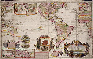
| Description From Source | Full title Carte nouvelle de la Mer du Sud [cartographic material] : dressée par ordre des principaux Directeurs & tirée des memoirs le plus recents et des Relations des navigateurs les plus modernes : tant de France que d’Espagne : l’on yä joint, diverses remarques curieuses par raport aux decouvertes des graduations des manierres du pais que de la navigation / donné au public par And. & Henry de Leth à Amsterdam sur le Pont de la Bourse au Pescheur. Physical Description Cartographic data Scale [ca. 1:31,000,000] Physical content 1 map : col. ; 56.1 x 91.7 cm. Contents Insets: Vera-Cruz. Scale not given — Baye de Rio Janeiro. Scale [ca. 1:270,000] — Le Havane. Scale [ca. 1:5,265] — Le Detroit de Gibaltar. Scale not given — Baye de Porto Bello. Scale not given — Isthme de Panama ou de Darien. Scale [ca. 1:2,666,000]. General note Decorative features include: Cartouche decorated with a lion, a leopard, a fox and monkeys at bottom right hand corner of map, showing the settlement of Cape Town and its shipping — Decorative cartouche at centre bottom of map showing the religious practices of Indians in Mexico — Vignette of native life in the French Islands. Explanatory text in Dutch at bottom right of centre on map: Nieuwe Kaart van de Zuyd Zee … . Explanatory text in Latin at bottom left of map: Nova Maris Pacifici Tabula … . Imprint in Dutch on map: Uyt gegeven door And. en Hend. de Leth tot Amsteldam op de Beurs-Zluys in de Visser, [1740]. Imprint in French on map: Amsterdam : Donné au public, par Aud. & Henry de Leth, [1740]. Includes text and ill. Prime meridian: Ferro. Probably vol. 3, no. 94 from: Nieuwe atlas inhoudende de vier gedeeltens der waereld … versameldt van de beste autheuren. Te Amsterdam : Bij Johannes Covens & Cornelius Mortier, 1707-1741. This highly decorative map highlights the continent of North and South America, featuring California as an island, as well as the Pacific and the Atlantic oceans. It also includes Nouvelle Hollande [i.e. Australia] and Nouvelle Guinea [i.e. New Guinea], both distortedly represented, with a portion of South-East as well as the west coast of Africa. In particular, note that the ‘Solomon Islands’ are depicted next to Carpentaria which extends into Terre de Quir and joins ‘Nouvelle Zelande’. The sea tracks of explorers are included. The map also includes many vignettes, annotations and some insets. Relief is shown pictorially. Exhibited in: Crux. Rare maps from the State Library of NSW Mitchell Library copies at: Z/ M4 120/ 1740/ 1 and Z/ M4 120/ 1740/ 3 : Information transferred from the Mitchell Library shelflist catalogue as part of the eRecords Project 2009-2010. Mitchell Library copy at: Z/ M4 120/ 1740/ 2 and Z/ M4 120/ 1740/ 3 : Transferred from F2/8. |
| Physical Format | Maps |
| Related Resources | https://nla.gov.au/nla.obj-232611826/view |
Related files
Post successfully! Your comment will appear after it has been approved by the admin.
Log In to add your own notes to this record.
Saved to collection